 CulturalInscribed 2004
Iran (Islamic Republic of)
About This Site
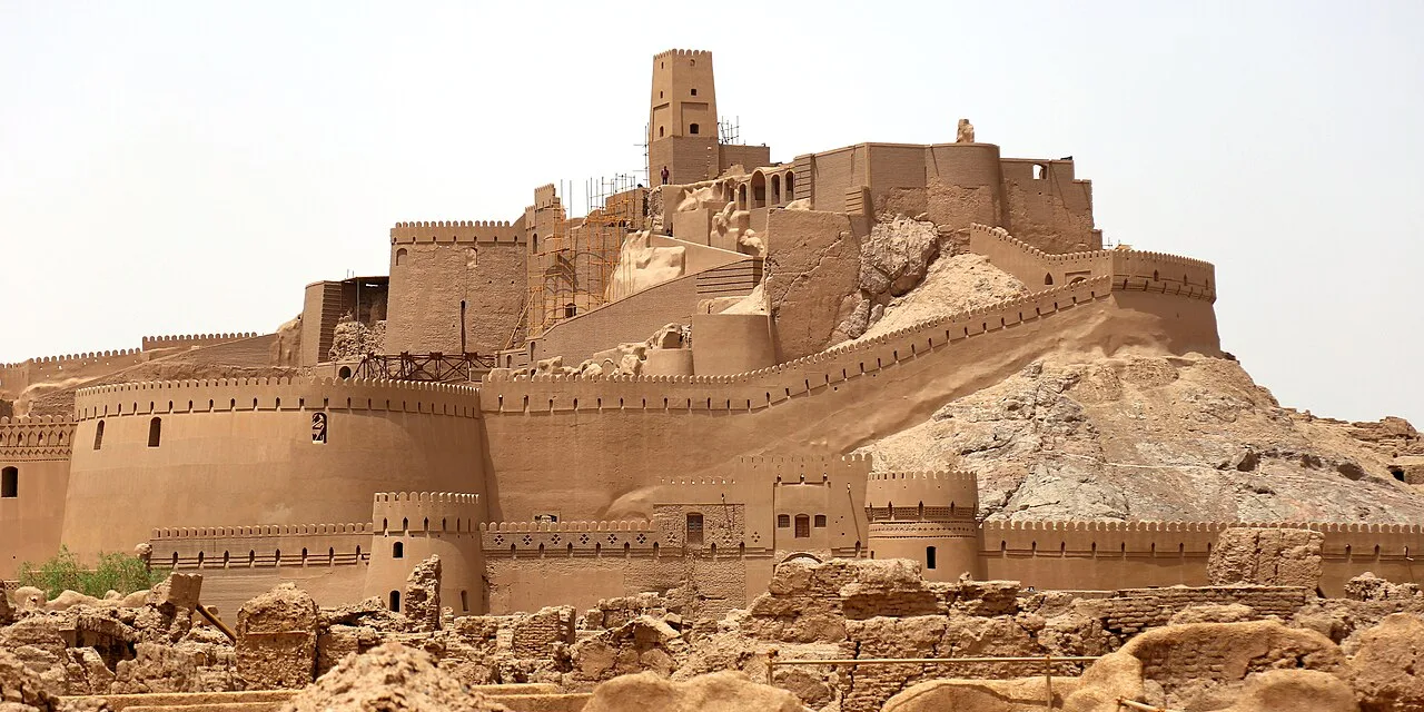
Bam is situated in a desert environment on the southern edge of the Iranian high plateau. The origins of Bam can be traced back to the Achaemenid period (6th to 4th centuries BC). Its heyday was from the 7th to 11th centuries, being at the crossroads of important trade routes and known for the production of silk and cotton garments. The existence of life in the oasis was based on the underground irrigation canals, the qanāts, of which Bam has preserved some of the earliest evidence in Iran. Arg-e Bam is the most representative example of a fortified medieval town built in vernacular technique using mud layers (Chineh ).
Site Details
| Category | Cultural |
| Date Inscribed | 2004 |
| Area | 2,761 hectares |
| Cultural Criteria | c2, c3, c4, c5 |
| Location | Iran (Islamic Republic of) |
| Coordinates | 29.1168, 58.3667 |
Inscription Justification
Brief synthesis The property of Bam and its Cultural Landscape is located on the southern edge of the Iranian high plateau, in Kerman Province, in south-eastern Iran, close to the Pakistan border. Bam lies 1,060 metres above sea level in the centre of the valley dominated to the north by the Kafut Mountains and to the south by the Jebal-e Barez Mountains. This valley forms the wider cultural landscape of the Bam County. Beyond the mountains lies the vast Lut Desert of Central Iran. Water from the Jebal-e Barez Mountains supplies the seasonal Posht-e Rud River that skirts Bam City between Arg-e Bam and Qal’eh Doktar. The Chelekhoneh River and its tributaries gather water from the central parts of the Jebal-e Barez Mountain range. It now runs northeast, although it formerly flowed through the Bam City until it was diverted by a dam into a new course that met with the Posht-e Rud northwest of Bam City. Water from the Kafut Mountains also supplies the catchment area. The origins of the citadel of Bam, Arg-e Bam, can be traced back to the Achaemenid period (6th to 4th centuries BC) and even beyond. The heyday of the citadel was from the 7th to 11th centuries, being at the crossroads of important trade routes and known for the production of silk and cotton garments. The citadel, which contains the governor’s quarters and the fortified residential area, forms the central focus of a vast cultural landscape, which is marked by a series of forts and citadels, now in ruins. The existence of life in the oasis was based on the underground irrigation canals, the qanāts, of which Bam has preserved some of the earliest evidence in Iran and which continue to function till the present time. Arg-e Bam is the most representative example of a fortified medieval town built in vernacular technique using mud layers (Chineh), sun-dried mud bricks (khesht), and vaulted and domed structures. Outside the core area of Arg-e Bam, there are other protected historic structures which include…
Other World Heritage Sites in Iran
Cultural · Inscribed 2025Prehistoric Sites of the Khorramabad ValleyCultural · Inscribed 2024HegmatanehCultural · Inscribed 2023The Persian CaravanseraiCultural · Inscribed 2021Trans-Iranian RailwayCultural · Inscribed 2021Cultural Landscape of Hawraman/UramanatNatural · Inscribed 2019Hyrcanian Forests
More cultural heritage sites
TurkmenistanState Historical and Cultural Park “Ancient Merv”IndiaHumayun's Tomb, DelhiTürkiyeHistoric Areas of IstanbulIndiaAjanta CavesTürkiyeCity of SafranboluIndia, Japan, France, Belgium, Switzerland, Argentina, GermanyThe Architectural Work of Le Corbusier, an Outstanding Contribution to the Modern Movement
Sites inscribed in the 2000s
- Kinabalu Park (2000, Malaysia)
- Land of Frankincense (2000, Oman)
- Walled City of Baku with the Shirvanshah's Palace and Maiden Tower (2000, Azerbaijan)
- Gunung Mulu National Park (2000, Malaysia)
- Historic Centre of Shakhrisyabz (2000, Uzbekistan)
- Masada (2001, Israel)
- Old City of Acre (2001, Israel)
- Samarkand – Crossroad of Cultures (2001, Uzbekistan)
Data Source: UNESCO World Heritage Convention